OSPREY for First Responders and Emergency Managers
Main_Content
 These tools are designed for use by the public safety community and emergency management. The tools provide both a high level view of a situation and decision making analytics. These tools are not for public use - they are secure, requiring logon credentials. MD GeoShare Form to request login
Center_Content
Maryland Geo Share is the second of Maryland's ArcGIS Online Organizations. This resource is an online collection of data, maps, apps, tools, and geographic knowledge, built to maintain a strong relationship between Local, Regional, Universities and State GIS. It also offers access to groups committed to sharing data and information during emergencies and steady state to help Maryland be a more resilient, prepared, and responsive state.
MD Geo Share is a platform that not only allows local, regional and university GIS users to collaborate with the State and each other, but also allows the State to collaborate with the Federal Government Agencies.
An additional benefit is the ability for Emergency Managers and GIS users within Local Jurisdictions to host and maintain a suite of damage collection tools. The Damage Collection Web Map, Collector App, and Operation Dashboard are all available to jurisdictions willing to engage them with State support.
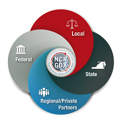
The NCR GDX allows local, regional, state, and federal participants to securely share critical information among emergency management systems. Sharing privileges are managed by the organization supplying the data and enforced for all. Available data includes GIS and CAD data feeds.
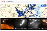
MView provides CCTV camera feeds from multiple organizations in Maryland and the National Capital Region to authorized users. Users are granted access to specific groups of camera feeds from the various organizations based on their login credentials. As of April 2015, MView has over 3,300 cameras from 35 organizations and close to 2,000 users from over 100 organizations and growing daily. MView accounts are currently available to first responders, law enforcement, emergency management, and public safety personnel and other government officials with a need-to-know.

Developed by the University of Maryland the Regional Integrated Transportation Information System (RITIS) combines data from SHA and commercial sources to provide a very complete and intuitive picture of traffic in a multi-state region. The public version does not require a password.
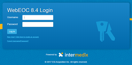
WebEOC is used by MDEM to manage incidents. Based on the Incident Command Structure (ICS) information and requirements for assistance are compiled from state agencies, local governments, utilities and others. WebEOC is where this information comes together. WebEOC is used to help produce the situation reports that are regularly issued by MDEM during activations. To request an account please contact the Maryland Emergency Management Agency.

HC (Healthcare) Standard is MIEMSS’ platform for the statewide EMS communications system. The platform enables real-time status and data sharing across local and state medical facilities. HC Standard provides county hospital alerts (CHATS), facilities resources (FRED), county hospital requests (CHRS) and patient tracking.